| YEAR | NAVIGATORS | VESSELS | LOCATIONS | KEY EVENTS | KEY REFERENCES |
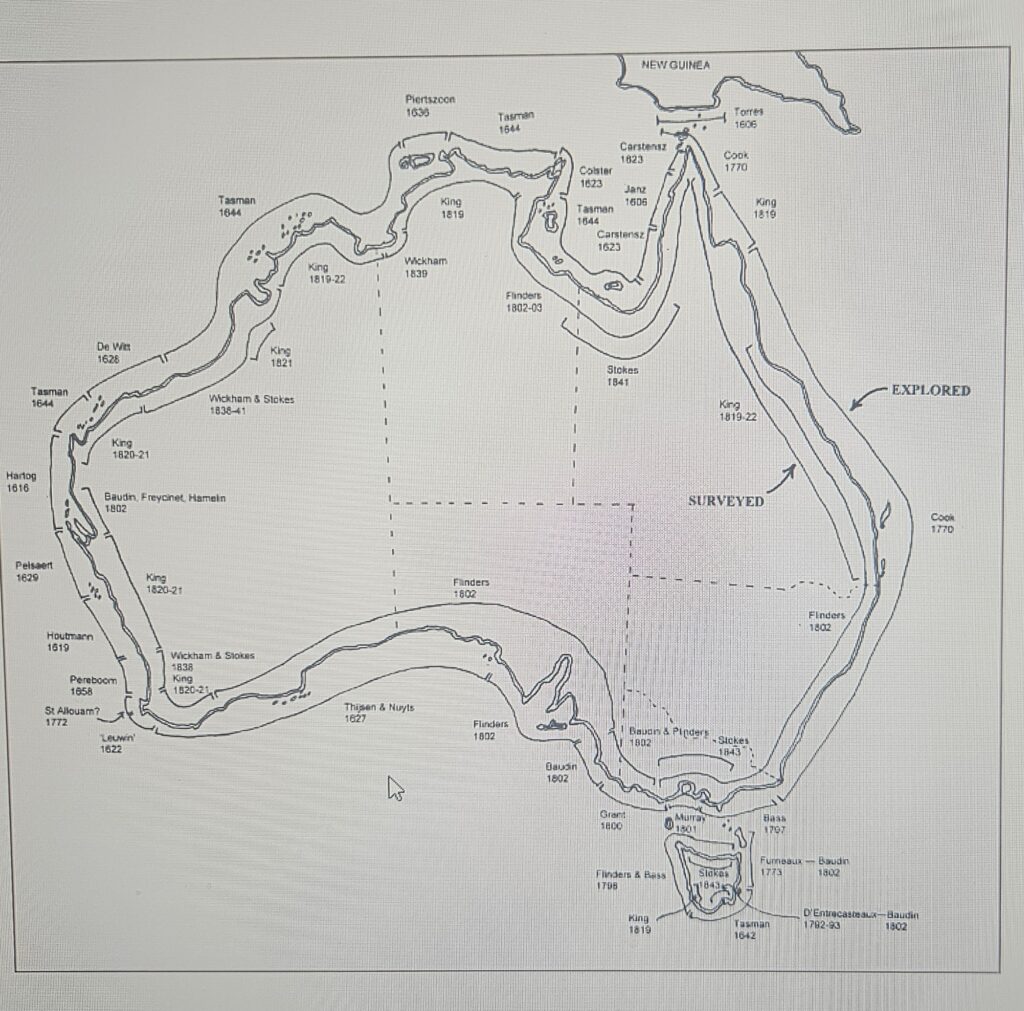
| 1616 | Dirk Hartog | Eendracht | Dirk Hartog Island | 1st recorded sighting of west coast of Australia. Arrived 25 October, sailed 27 October. Left Hartog Plate. | Major pp.ixxxi-xxxiv; Heeres pp.8-10 |
| 1618 | Haevik Claesz. van Hillegom | Zeewolf | North West Cape | Sighted North West Cape on 11 May. | Heeres pp.10-12 |
| 1618 | Lenaert Jacobsz. | Mauritius | North West Cape; Willems River | July 31, both Antony van Diemen and Willem Janszoon were aboard. Willems River (Yardie Creek) named after Janszoon. | Heeres pp.12-13; Schilder p.72 |
| 1619 | Jansz. Reiner, Kornelisz. Marten | Dordrecht, Amsterdam | Lower west coast up to North West Cape | Frederik de Houtman and Jacob Dedel aboard. Charted Dedel’s Land, part of Rottnest Island and Houtman Abrolhos Islands. | Heeres pp.14-16; Schilder pp.75-77 |
| 1622 | Jan Franssen or Fransz. van Hoorn | Leeuwin | Cape Leeuwin and south coast for 150 kms | First sighting of Cape Leeuwin and charting of south coast of Australia. | Heeres p.18. |
| 1622 | Roelof Pietersz. | ‘t Wapen van Hoorn | Probably Edel Land (western most peninsula of Shark Bay or Dirk Hartog Island | Ran aground June 1622, refloated. | Heeres p.18 |
| 1623 | Claes Hermanszoon | Leijden | South of Dirk Hartog Island | 1st European baby born in Australian waters. | Heeres p.49 Estensen p.152 |
| 1626 | Daniel Cock | Leijden | Zuytdorp Cliffs to Dirk Hartog Island | Sighted coast but did not land. | Heeres p.50 Estensen p.152 |
| 1627 | Commander Peter Nuyts, Skipper François Thijssen | ‘t Gulden Zeepaert | Charted south coast of Australia as far as Fowler’s Bay, SA | First extensive charting of south coast and of SA coast. | Heeres p.51; Schilder pp.106-7 |
| 1627 | Jan Pietersz Coen | Galias, Utrecht, Texel | Lat. 280 30′ S, almost strike reefs around Abrolhos Islands | Governor General of Indies, Jan Pieterszoon Coen aboard Gallias (incognito). Recommends more detailed charting of Southland by Dutch East India Company. | Heeres p.51-2 |
| 1627 | Commander J. van Roosenburgh, Skipper David Piertsz. de Vries | ‘t Wapen Van Hoorn | Near Dirk Hartog Island | Charting leads to revisions to map of Eendracht Land. | Heeres p.52-3 |
| 1628 | Gerrit Frederiksz. de Witt | Vianen | North west coast (de Witt’s Land) | Chart 370 kms of north west coast. | Heeres p.54 Estensen p.155 |
| 1629 | Francisco Pelsaert | Batavia | Northern Group, Houtman Abrolhos Islands | Ship wrecked on June 4 on Morning Reef and Batavia Mutiny follows. First European structures built in Australia (still extant). First description of an Australian marsupial. | Heeres pp.58-62 |
| 1629 | Francisco Pelsaert | Sardam | Houtman Abrolhos Islands | Returns with rescue ship in September, puts down Mutiny, tries mutineers, salvages material from wreck, maroons 2 mutineers on mainland (probably at Hutt River), before taking survivors back to Batavia. | Major pp.59-74 Heeres pp.58-62 |
| 1635 | Wijbrandt Geleynsz. de Jongh | Amsterdam | West coast around 250 S | Charted stretch of coast | Heeres pp.62-64 |
| 1644 | Abel Tasman | ||||
| 1648 | Jan Jansz. Zeeuw | Leeuwerik | Western Australian coast 25-260 S | Journal and charts missing. | Heeres pp.73-74 |
| 1656 | Pieter Albertsz. | Vergulde Draeck | Off Ledge Point, 95 kms north of Perth | Struck reef 5 kms off the coast on night of 28 April. 75 people made it to shore, 7 sent in boat to Batavia to raise the alarm, remaining 68 never seen again despite numerous searches. | Heeres pp.75-76 |
| 1656 | ? | Goede Hoop & Witte Valcq | Vessels sent to search for survivors along part of coast where Vergulde Draeck sank | No sign of Skipper and crew of Vergulde Draeck, not found, Goede Hoop loses 11 men on the coast during the search. | Heeres pp.75 |
| 1657 | Joost Jansz. | Vincq | Sailing from Cape of Good Hope, conducts search in area where Vergulde Draeck sank | Encounters stormy weather and has no success in search for survivors of Vergulde Draeck. | Heeres pp.75-77 |
| 1658 | Samuel Volckersen, Aucke Pieter Jonck | Waekende Boey & Emeloordt | Conduct another search for survivors of Vergulde Draeck along coast where it sank | Remains of wreck and campsite found but unable to relocate survivors; land on Rottnest Island; make first European drawings of Australia. | Heeres pp.76-80 |
| 1658 | Jacob Pietersz. Peereboom | Elburgh | Cape Leeuwin and Cape Naturaliste area | Brief encounter Wardandi Aboriginal people. They flee and leave behind fire, tools and huts. | Heeres pp.81 |
| 1659 | Dirk Dirksz. Jonas | Immenhorn | West coast in vicinity of where Vergulde Draeck sank in 1656 | Last ship sent to search for survivors of Vergulde Draeck, unable to land because of bad weather. | VOC website |
| 1678 | Jan van der Wall | Vliegende Zwaan | North west coast | Further charting of north west coast from North West Cape to Roebuck Bay. | Heeres pp.81-2 |
| 1696-7 | Willem de Vlamingh | Geelvinck, Nijptang, Weseltje | From Perth region to North West Cape | Chart and explore Swan River, visit Rottnest Island, remove Hartog Plate, replacing with Vlamingh Plate; Artist Victor Victorsz. produces numerous coastal profiles. | Heeres pp.83-86 |
| 1712 | Marinus Wijsvliet | Zuytdorp | 60 kms north of mouth of Murchison River | Wreck and survivor’s campsite come to light in 1927. Coins establish identity of wreck. Unknown number of survivors (40-140) moved away. | Estensen pp.203-204; Henderson p.35 |
| 1727 | Jan Steyns | Zeewijk | Pelsaert Group, Houtman Abrolhos Islands | Longboat sent for help but disappears. Crew then construct their own longboat, Sloepie, 1st European vessel built in Australia, and sail to Batavia. | Heeres p.91 |
References
Estensen, M. 1998 Discovery – The Quest for the Great South Land, Allen & Unwin, Crows Nest.
Heeres, J.E. 1899 The Part Borne By The Dutch in the Discovery of Australia 1606 – 1765, E J Brill, Luzac and Co, London, Leiden.
Henderson G. 1980 Unfinished Voyages – Western Australian Shipwrecks 1622-1850, University
of Western Australia Press, Nedlands.
Major, R.H. 1859 Early Voyages to Terra Australis, Hakluyt Society, London.
Schilder, G. 1976 Australia Unveiled: The Share of the Dutch Navigators in the Discovery of Australia, Theatrum Orbis Terrarum, Amsterdam.
Source: Great Southern Land: the Maritime Exploration of Terra Australis