Recent scientific research (2025) has completed the first comprehensive geological mapping of Zealandia, a vast continent that lies almost entirely beneath the waters of the southwest Pacific. Covering approximately five million square kilometres, Zealandia is around two-thirds the size of Australia, yet some 95 per cent of it is submerged beneath the ocean. For many scientists, its recognition as Earth’s eighth continent has become one of the most remarkable geological discoveries of modern times.
For those interested in Dutch-Australian history, however, Zealandia offers something more. It provides a fascinating new perspective on one of the most important voyages in the history of exploration: Abel Tasman’s expedition of 1642–43.
The search for Terra Australis
When Abel Tasman departed Batavia in August 1642 on behalf of the Dutch East India Company (VOC), he was entering a largely unknown part of the world. European geographers had long believed that a vast southern continent existed. Known as Terra Australis Incognita, this hypothetical landmass appeared on many maps despite no European having proven its existence.
The VOC had both commercial and strategic reasons for supporting exploration. New lands might provide trading opportunities, resources, or navigational advantages. At the same time, each voyage expanded Dutch geographical knowledge and reinforced the Republic’s position as the world’s leading maritime power.
Tasman’s expedition took him into waters rarely visited by Europeans. During the voyage he became the first known European to sight what he named Van Diemen’s Land, now Tasmania. Continuing eastward, he reached the west coast of New Zealand and charted parts of its coastline before sailing north through the Pacific.
Although Tasman never found the great southern continent imagined by European cartographers, his voyage fundamentally altered European understanding of the region. His discoveries would later play an important role in the mapping and exploration of Australia, New Zealand and the Pacific.
What Tasman could not know
Like many explorers of his era, Tasman believed that the lands he encountered might be connected to a much larger continent. In this respect, modern science has revealed a remarkable irony.
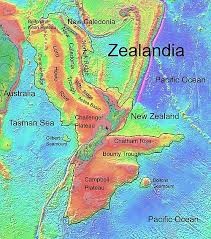
Geologists now understand that New Zealand is not simply a collection of isolated islands. Instead, it forms the highest part of Zealandia, a continental landmass that separated from the ancient supercontinent Gondwana approximately 80 million years ago.
Over millions of years, most of Zealandia gradually subsided beneath the ocean. Only a few regions remained above sea level, including New Zealand, New Caledonia and several smaller island groups. The continent itself remained hidden, its existence impossible to recognise before the development of modern geology and marine surveying techniques.
When Tasman sailed along the coast of New Zealand in 1642, he was therefore looking at the exposed peaks of a continent that lay largely beneath the sea. The mountains and coastlines visible from his ships were not merely islands in the conventional sense, but fragments of a much larger geological structure extending across millions of square kilometres.
The connection with Australia
The story of Zealandia also highlights the deep geological relationship between Australia and New Zealand.
Both continents were once part of Gondwana, alongside Antarctica, South America, Africa and the Indian subcontinent. Zealandia eventually drifted away from Australia and Antarctica, becoming isolated in the southwest Pacific. As the continent subsided, only its highest regions remained above water.
For Australians, this discovery adds another dimension to the story of European exploration in the region. Tasman’s voyages connected Tasmania, New Zealand and the wider southwest Pacific in ways that were not fully understood at the time. Today, geology reveals that these places also share an ancient continental history stretching back tens of millions of years.
A new perspective on an old voyage
The scientific mapping of Zealandia does not change the historical achievements of Abel Tasman. His significance as one of the great Dutch navigators remains firmly established. What the discovery does offer is a fresh way of viewing his remarkable journey.
Tasman was searching for Terra Australis, a continent that European mapmakers imagined but could not prove. He never found the vast southern continent that appeared on seventeenth-century maps. Yet modern science has revealed that he was sailing among the visible remnants of another continent entirely.
Nearly four centuries after his voyage, geology has added an unexpected chapter to the story. The coastlines Tasman charted in 1642 were part of Zealandia, a continent hidden beneath the Pacific Ocean for millions of years. In a curious twist of history, the Dutch navigator who failed to find the continent he was seeking may have unknowingly encountered the edge of one that science would only recognise centuries later.
Further reading
Readers interested in Abel Tasman’s voyages and their significance for Australia and New Zealand can explore the extensive material available elsewhere on this website, including articles on Tasman’s voyages, historical maps, artistic depictions and the broader story of early Dutch exploration in the Australasian region.